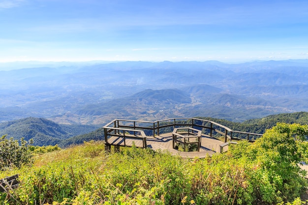
There’s a stretch of road between Kozhikode and Wayanad that everyone who’s driven it seems to remember the same way — nine hairpin bends, climbing through forest so thick you lose the plains behind you without really noticing it happen. By the ninth bend, at a spot called Lakkidi, the land just opens up. Fog sitting in the valley, tea gardens running down the slopes, and that particular quiet you only get at altitude. Most people who’ve made this drive will tell you it’s the moment the trip actually starts.
Here’s what you actually need to know before you go — how to get there, when to time it, and what’s worth doing once you’re standing at the railing.
So what is Lakkidi, exactly?
Lakkidi sits at about 700 metres above sea level, right where the Thamarassery ghat road finishes its climb from Kozhikode up onto the Wayanad plateau. That climb — locally called the Thamarassery Churam — runs roughly 12 kilometres from Adivaram at the base, working through nine numbered hairpins cut into the forest.
The number that actually explains the place, though, is the rainfall. Lakkidi gets cited again and again as one of the wettest spots in Kerala — figures around 600 cm a year get thrown around, and some sources rank it among the wettest points anywhere on earth. You feel that the moment you step out of the car. Mist most mornings, moss climbing over every rock face, and a shade of green that looks almost too saturated, especially once you’ve spent an hour driving through the drier country below.
A little history — and one thing nobody can quite explain
This part of the forest isn’t scenic by accident of history alone. Pazhassi Raja, the Kottayam-region ruler who fought British colonial forces through the late 1700s and into the early 1800s, used this exact terrain to his advantage. His fighters — many of them local tribal warriors who knew the land in a way no outside army ever could — ran ambush after ambush out of this stretch of forest. It’s a real reason the British struggled here for years, and it’s a large part of why Pazhassi Raja is still spoken about locally with something closer to reverence than a textbook footnote.
There’s a stranger story too, tied to a spot near the viewpoint known as the Chain Tree — a large ficus with a heavy iron chain wrapped around its trunk. Ask three different locals why it’s there and you’ll likely get three different answers: an old punishment, a protective ritual, a warning of some kind. Nobody seems to agree on one version, and that’s honestly part of the appeal. It’s the sort of detail a guide will tell you if you ask, but you won’t find it in most write-ups.
Getting there
Most visitors come up from Kozhikode, and depending on exactly where you start in the city, that’s somewhere between 41 and 58 kilometres — call it an hour and a half. Kozhikode has the nearest railway station, and Calicut International Airport is about 44 km from the viewpoint, which makes the city the obvious entry point if you’re flying in.
If you’re already in Wayanad, Vythiri is only about 5 km away and has decent bus and taxi links, with Kalpetta a little further at around 15 km.
The drive itself is part of why people remember Lakkidi. Roadside stalls sell tender coconut and hot tea along the way, and monkeys turn up on the roadside more often than not, so if you stop for photos, keep an eye on anything edible in the car.
When to go
People genuinely disagree on the best season here, and honestly, that’s because there isn’t a bad one — just different versions of the same place.
October through February gives you the clearest skies, and if sunrise or sunset photography is the point of the trip, this is the safer bet. The monsoon months — June to September — turn Lakkidi into the version it’s actually known for: heavy mist rolling through, clouds moving fast enough to watch in real time, rain that lives up to the reputation. You might not get a clean view, but the atmosphere more than makes up for it.
Early mornings, roughly 6 to 9 AM, tend to have the best light no matter the season, and weekday crowds are noticeably thinner than weekends. There’s no entry fee and no fixed closing time, but most guides will tell you to be gone before dark — there’s no lighting up there, and the drop-offs aren’t something you want to navigate blind.
What you’ll actually do once you’re there
There’s no ticket counter here and nothing to check off a list. Most people just park, walk to the railing, and stand there for twenty or thirty minutes — which sounds like nothing until you’re actually doing it and tracing the ghat road switching back on itself far below, framed by tea estates and unbroken forest running to the horizon.
Photographers tend to linger for sunrise or sunset, though how much of the view actually shows up depends entirely on the clouds, which shift fast at this elevation — sometimes faster than you can get the camera up. A few informal trails wander off from around the viewpoint into the forest, generally short enough for an hour or two, but they’re not marked or maintained the way something like the Chembra Peak trek is, so treat them as a casual walk rather than a hike, and don’t go far without someone who knows the terrain if you’re not from the area.
If you’re into birds, the forest here holds a decent range — hornbills, woodpeckers, various sunbirds — and early morning, when things are quiet, is by far the best window to catch them.
Rounding out the day
Because Lakkidi sits right at the edge where the plains give way to the hills, it works well as either the first or last stop on a longer Wayanad loop. Pookode Lake is close by, about 3 to 4 km away — a freshwater lake popular for boating, with a shape often compared to the outline of the Indian subcontinent. Chembra Peak is further out, around 30 km, and one of Wayanad’s highest points; it’s home to the well-known heart-shaped lake partway up the trek, though unlike the walks around Lakkidi, this one needs a permit and a guide.
Banasura Sagar Dam is about 25 km away and one of the largest earthen dams in India, with its own boating and reservoir views. Edakkal Caves, roughly 35 km out, hold rock engravings researchers date back thousands of years — worth the detour if prehistoric archaeology interests you at all. And if casual birdwatching isn’t enough, Tholpetty Wildlife Sanctuary further north is a proper wildlife-spotting destination in its own right.
None of these are close enough to stumble into by accident, so it’s worth mapping a rough loop rather than trying to squeeze all of it into one afternoon.
A few things worth knowing before you go
Wear shoes with real grip — the ground near the edges gets slick fast, especially right after rain.
Watch your food around the monkeys. They’re used to people, and they’re not shy about it.
There’s no entry fee and no gate hours, which also means there’s no formal safety barrier everywhere it might matter — use common sense near the drop-offs.
And if the mist is too heavy for that sunrise shot you had planned, don’t force it. Sometimes the fog curling through the valley ends up being the better photo anyway.
Lakkidi was never meant to be a full-day stop, and that’s really the point of it. It’s a pause built into the geography — the exact spot where the climb ends and Wayanad’s hills open up in front of you. Give it half an hour or give it two hours. Either way, it tends to set the mood for whatever’s next.